In case you were unaware, the Trans-Minnesota Adventure Trail has a branch that goes into Ontario loops around just west of Thunder Bay and returns. The total length of the “Canuck” loop is about 450 miles. This last September myself and MrFixIt decided pack 2 tents, 2 GoPros, a Honda and a Suzuki and ride this trail. The results are in the video below. All I can say is that Canada has some amazing scenery, great terrain, and very welcoming people. I hope to ride more of the country soon, and I hope you get a chance to experience it too. This kind of riding so close to us is a shame to pass up.
Video of the TMAT Canuck Loop
December 25, 2013
 2 Comments |
  Trails |
  Permalink
 Posted by Travel Guide
Photo Montage of Recent Trip on the TMAT
November 26, 2013Jim Klas recently posted this collection of photos to our Facebook page after a trip along the TMAT this fall.
“Late August 2013 trip, starting at Duluth Minnesota traveling north to Ely, then north on the Echo trail to Internal Fall and Voyager National Park. Leaving the Canadian border traveled south to Iowa, traveling on dirt with pavement connectors. Great solo motorcycle ride.” -Jim Klas
I must say, this set very much captures what the Trans-Minnesota Adventure Trail is all about. From the deep woods in the north, to the bogs along the Gandy Dancer, to the bluffs in the south, it’s all there. Very well done. Take a few minutes to click through and enjoy. Thanks for posting Jim!

What is the Trans-Minnesota Adventure Trail (TMAT)?
September 13, 2013The Trans-Minnesota Adventure Trail has been in existence for a few years now, but I still get questions about what it is and how to get more info. In fact, many of the riders becoming members of www.MinneADV.org say they don’t know what the TMAT is. So I thought an updated blog post might be in order.
A few years ago I became a bit frustrated that there wasn’t one place a new dual-sport or adventure motorcyclist in Minnesota could go to find trails to ride. The DNR does a good job with its website and paper maps, but the OHM (off highway motorcycle) areas they support are targeted at the dirt bike crowd. Other riders I spoke to had the same frustration. After spending a day riding the Trans-Wisconsin Adventure Trail, I thought, “Gee, why doesn’t Minnesota have one of these?”. The Wisconsin trail had a website for more info, GPS tracks, and a following of riders that contributed to curating the route.
So with that, the idea for the TMAT was born. I started gathering DNR maps, county maps, national forest maps, satellite imagery, etc. I also started soliciting rider help on ADVrider.com and from people I met at rider gatherings. Finally, I just got out and started riding the routes. What I found was that there were many good off-pavement riding areas in Minnesota, and those areas connected together quite nicely with scenic pavement routes. The master route spanned across the entire state from south-eastern MN to International Falls. It went through popular areas like the Zumbro bottoms, Nemadji state forest, and Superior National forest. Many many thanks go out to all the riders who contributed to this and helped prove out the routes. Within a year the eastern route was complete.
Eastern Route:
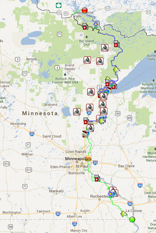
MinneADV.info was started to blog about the process, and host the GPS files. Later we moved the files to DualSportMaps.com since their site and tooling is really the best on the web for this sort of thing. We now also have MinneADV.org as a place for riders to post group rides and events, and meet other Minnesota riders. We now have hundreds of followers of the blog and over 80 riders on the meetup site. The TMAT is also consistently one of the most popular maps on DualSportMaps.com. The trail has also been extended to include a TMAT Central route so that riders from the western parts of the state can hop on and connect to other trails.
Central Route:
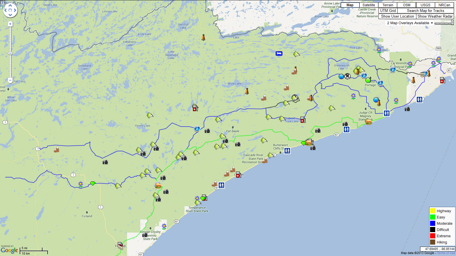
The best trails on the TMAT are not found along the main Central and Eastern routes however. The TMAT has expanded to include “loops”. The loops target prime areas of the state where the best trails are. They are meant for someone who doesn’t want to travel across the state, but rather wants to loop through an area for a day or weekend and come back home. For example, the Gunflint loop branches off from the TMAT East and has some of the most scenic views in the state.
Gunflint Loop:
If you want more info on the TMAT and all the related loops, including the GPS files, you can find it here. Keep checking back. The trail is always maturing and growing.
If you’d like to see photos and videos of the trail you can find that here as well. Use the Contact Us link if you want to send in your own photos or video. They are always welcome! Use the link to send ideas for new route modifications too.
Minnesota is a beautiful and rugged state, perfect for Adventure riding. If you haven’t ridden the TMAT yet, there is no excuse. There are over a thousand miles of trail. A section of it is likely just short ride from your front door. Get out and enjoy it.
Leave a Comment » | Trails | Permalink
Posted by Travel Guide
Chengwatana Ride Report
September 5, 2012Just a quick ride report from this last Sunday in the Chengwatana State Forest. If you haven’t been to this area before it is a small state OHM and ATV trail system, but one of the closest to the Twin Cities area. I had my son in tow riding a DR250. It was his first time on a real trail and he had a great time. The photo below shows him trying to get up the only hill climb on this trail which can be pretty gnarly. The rocks in the photo are not limited to this hill. Almost the entire trail has good sized rocks and ruts.
My advice if you go to this state forest? If you go on the weekends, get there early, like 8 or 9 AM before the ATVs arrive. Many of the trails are twisty single or double track and running into an ATV head-on is no fun. I have no idea why the DNR doesn’t make these trails one-way only.
I would also suggest only planning 2-3 hours of riding here as the trails system is very short. I also have no idea why they don’t connect this trail system with the St. Croix forest trail system just a few miles to the North. This would make a much larger and more attractive tourist destination for very little investment. You can always jump on the county highway to get up to St. Croix or Nemadji though, and the Trans-Minnesota Adventure Trail GPX files will guide you on the quickest route.
Be sure and visit http://www.MinneADV.info for the latest on organized rides for September and October. New rides were just posted.

Leave a Comment » | Trails | Permalink
Posted by Travel Guide
TMAT Gunflint Loop Ride Report
July 2, 2012Last week a fellow rider and myself trailered up to Two Harbors and set off from there to explore the “Gunflint Loop”. This was just a week after the historic floods that hit that area so we didn’t know quite what to expect in the way of washouts or road closings. We also hoped to have enough time to explore a bit on the Canadian side of the border in the “Canuck Loop”.
This is one of the most scenic areas of Minnesota. I have visited the area several times before as a tourist but never on motorcycle, so I was excited to explore some new territory. Once unloaded in Two Harbors we headed for the nearest road on the TMAT. Unfortunately Alger Grade was a known washout from the storms, so we had a slight detour around it. We followed the Gunflint Loop GPS track the rest of the day north and north east and passed just to the west of Beaver Bay and Silver Bay. The gravel roads were in very good condition and even a little dry after a week of hot sun. We made our way past Tettegouche State Park and through Finland. Cramer Road was especially scenic with creeks and streams that were way above their normal water level. We followed what we hoped were a couple double track shortcuts but both turned out to be dead ends. We shot past Nine Mile lake, Four Mile Lake, and Toohey Lake, then transferred onto “The Grade” which led to Saw Bill Trail. Sawbill was a fun stretch of roller coaster like gravel that led to Sawbill Lake and Campground. It was getting a bit late so we decided to camp there. The fact that they had cold beer and hot showers influenced our decision greatly. Temps were perfect for tent camping.
The next morning after some freeze dried eggs and a hot shower were were off exploring again. We were a little tired of the National Forest gravel roads so exploring some tougher tracks was a priority. We decided to try to find a shortcut around Pine Lake and the old trestle bridge that once went over it. An ATV motorcycle trail partially gets you south of it, and from the gps it didn’t look much farther to get north to Lima Grade road. Boy was I wrong! After an hour of bushwacking and swatting flies, I ended up dead ended in a swamp. The two of us managed to get our bikes out of there, but by the time we were on high ground sweating, panting, and tired, my riding partner realized that his XR wasn’t shifting properly. Some cable adjustment managed to fix the problem temporarily but it seemed that the wet marsh had caused him to roast his clutch. We limped the bike over to Grand Marais for lunch and thought it over. We decided it would not be smart to cross the border with the bike in this condition even though it was only 30 minutes away. So we slabbed it back on Hwy 61 to the truck and trailer. About a mile from the truck my clutch started slipping as well. I guess the mighty DR wasn’t immune to muddy clutch eating swamps either.
In the end we were disappointed not to make it to the border, but didn’t regret pushing our bikes (and ourselves) to the limits in order to explore and try something new. We will definitely be back to continue to the ride once some repairs are made. I encourage all the riders reading this to consider the Iron Range area for your next trip. It is extremely scenic with some of the most varied terrain in the state. Well worth your time.
Leave a Comment » | Trails | Permalink
Posted by Travel Guide
Matthew Lourey trail update!
May 17, 2012In a previous post I wrote about the need for riders to get involved and let the DNR know how much the proposed changes to the Matthew Lourey state trail would help them.
Yesterday I received an update from the DNR saying that the DNR Division of Parks and Trails approved the trail amendment!
This means that you will soon have an OHM alternative to the Gandy Dancer Trail when going between the St. Croix and Nemadji forests. The new trail is a total of 47 miles long and will provide a much more interesting ride than the Gandy for dual sports.
Keep in mind that more work needs to be done before the trail is “officially” open. It will take time to put up signs, update DNR maps, do some trail maintenance, etc. So look for an official grand opening later this year.
In the mean time check out this document for more info.
Thank you all that spoke up, wrote letters, and helped communicate to the DNR how important this trail is.
Leave a Comment » | Trails | Permalink
Posted by Travel Guide
Part of Soo Line trail opens to OHMs
May 9, 2012Good news! The Aitkin County board passed a new ordinance today allowing OHMs on the Soo Line North and Soo Line South trails. Not familiar with the Soo Line Trail system? It is a “rail to trail” system in northern Minnesota that flows east to west across the state. A have created a GPS map of the Aitkin County portion on dualsportmaps.com here: http://dualsportmaps.com/?link=104031.
This portion of the trail opening up in Aitkin county is important because it is the first step in getting ALL of the Soo Line opened to OHMs. Now some of you may ask why you would want a boring old railway bed as a dual sport trail, but realize that these trails provide important cross country travel for OHMs so that you do not have to get on an even MORE boring state or county highway to get to where you want to go.
A big shout out to the Minnesota DNR for working with local authorities to get this access for us. They will be updating their maps on their website soon. Let’s hope other counties see the benefit in opening up more trails to OHMs!
Leave a Comment » | News, Trails | Permalink
Posted by Travel Guide
Minnesota Adventure Riders FAQ
March 28, 2012I get emailed a lot of different questions from riders who stumble across this site so I thought it might be a good idea to create a post that answers a couple of them!
1. Where are the trails? Where is the TMAT trail? Do you have other trails or maps?
From the main page on http://www.MinneADV.info click on Trails>TMAT from the main menu. That will take you to a page with a link to the Central route and the Eastern Route. Follow those links and you will be directed to a website (dualsportmaps.com) that hosts the map. You can zoom in and out and scroll all around to see the route. If you want to download a .GPX file of the route for your GPS you can do that by creating an account on that site (Free!) and clicking the download button.
You can also click on the Trails>Other Trails link to find a list of other designated dual sport trails.
We do not have a printed map at this time, but that has been asked for and is in the works.
2. Do you organize rides? How do I meet other riders?
Riders from all over Minnesota organize group rides and “Meet and Greets” all the time. This website attempts to organize them in a way that is easy to find. Click on the Events link from the Main Menu to see a calendar of all the events. For example there is a “Tech Day” in April that guys from the tcdualsport mailing list do every year, and some folks from the advrider.com discussion board have a ride scheduled in May near Akeley. They are both on the Calendar.
You can also become a member of “MARs” (Minnesota Adventure Riders) by filling out this form. You will then have access to our forum where you can interact with other riders. Membership is currently free! You just need an active AMA membership number.
Leave a Comment » | Events, News, Trails | Permalink
Posted by Travel Guide
Matthew Lourey State Trail update. Help Needed!
February 27, 2012The DNR issued a news release today with an update on the pending Matthew Lourey OHM state trail. I have posted about this before and Minnesota Adventure Riders has written to the DNR commenting on how valuable this trail would be. In today’s news release the DNR states that they are moving forward with this trail and would like to get more feedback from the public on its use (Thrusday, March 8th in Rutledge). I encourage everyone to attend this meeting if you can. The state and local officials, as well as local members of the community need to know that riders like us bring economic benefit to their areas when they create great trails like this. If you cannot attend the meeting the press release gives the email addresses of two DNR employees to give your feedback to in written form.
PLEASE ATTEND THE MEETING OR EMAIL THESE DNR EMPLOYEES! This is how the DNR knows we exist and what our needs are. Most of them do not even know what an “Adventure Bike” is. So help them understand how much we appreciate their work, the access to trails, and ask how you can help. Specifically, you can tell them you would ALSO like to see a OHM trail connection between Chengwatana trail system and the Nemadji trail system. This would help cross country state travel IMMENSELY.
Today the TMAT travels through this part of the state on the Gandy Dancer trail and we are very thankful for that. However, the Matthew Lourey trail (47 miles) would be a more interesting trail for most riders as it is in a denser part of the forest and contains a much wider variety of terrain. As soon as the Matthew Lourey trail is opened officially the TMAT GPS files will be updated to use it instead of the Gander Dancy.
More information on the trail including a map can be found here. Word has it that during this calendar year a few other state trails may be opened up to OHM use which I am very excited about. Stay tuned for more info!

Leave a Comment » | Events, Trails | Permalink
Posted by Travel Guide
Where do you want to ride?
February 10, 2012The DNR is looking for your input. If you attended the motorcycle show this last weekend you may have noticed that the DNR was asking people to draw on a map where they wanted to ride. Well, I have scanned that map and put it online below. The map shows the state of MN and the current scenic byway roads. You can print the map, draw your routes, and mail it to the DNR. If you don’t know what to ask for, I would encourage you to ask for OHM access to the the following areas:
Soo Line Trail North and South
Blue Ox Trail
Lake County ATV Trail
A new OHM Trail between Chengwatana and St Croix State Forests
Mail it to this address:
Mary Straka
Off-Highway Vehicle Program
MN DNR Parks and Trails
1601 Minnesota Drive
Brainerd, MN
Or if it is easier to just describe your route in an email you can send it to the DNR here. We are lucky to have a state government organization that solicits our feedback. Please take advantage of this!


